| HOME | ABOUT US | DIRECTORS | CONTACTS | DONATE |


 |
Connections |  |


|
||
 |
 |
|
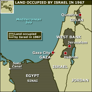 In the June, 1967 al-Naksah, or "the Setback," called the Six Day War in the West, Israel captured Sinai and the Gaza Strip from Egypt, East Jerusalem and West Bank from Jordan and the Golan Heights from Syria. Israel more than tripled the size of the area it controlled, from 8,000 to 26,000 square miles. According ot the UN, the conflict displaced another 500,000 Palestinians who fled to Egypt, Syria, Lebanon and Jordan. Immediately after the war, the Israeli government annexed extensive areas to the north, east and south of West Jerusalem to the Municipality of Jerusalem and began a rapid process to build settlements in these areas. Its goal was to prevent any challenge to Israel's sovereignty over them and to impede initiatives leading to an Israeli withdrawal from these areas. Israel also annexed a strip of land parallel to the Green Line along a few kilometers north and south of the Latrun area. This strip of land had been known as "no man's land," because in 1948-1967 it was not subject to the control of either the Israeli or the Jordanian side |
 |
| Education - committee |
|
| Humanitarian -committee |
|
| Development - committee |

|
| Cultural and Arts - committee |

|
| Media - committee |

|
| Dialogue & Outreach - Committee |
|
© 2013 Palestinians for Peace and Democracy. All Rights Reserved. Privacy Policy | Disclaimer